


TNO, KNMI and Whiffle Release New Dutch Offshore Wind Atlas
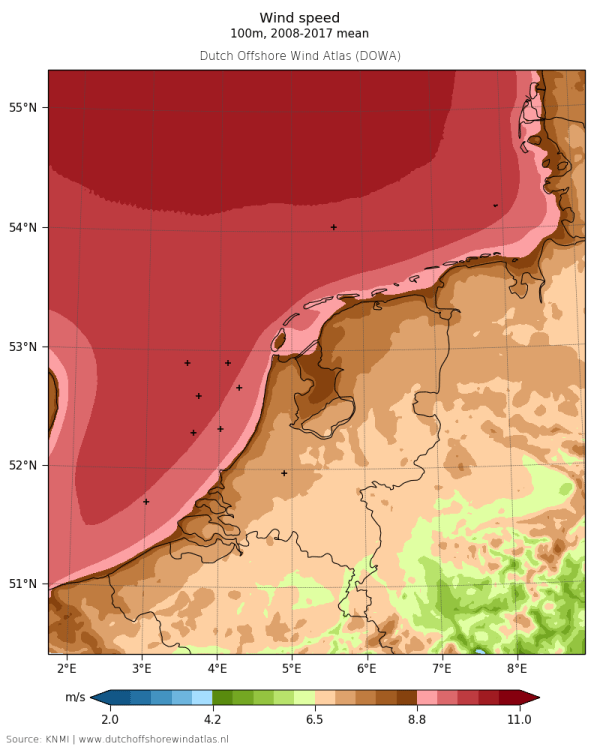 The ECN part of TNO, KNMI and Whiffle consortium will today release the new and improved Dutch Offshore Wind Atlas (www.dutchoffshorewindatlas.nl). It includes an unprecedented level of detail where the wind is mapped up-to 600m in height and the daily variability of the wind captured for all to view.
With this information the Dutch government and windfarm developers can plan, build and operate offshore wind farms even more efficiently. Deep understanding of our wind resource is key to cost effective implementation of large scale offshore wind energy. Both wind speed and direction are highly variable across the sea, not only in time but also in space. Uncertainty and variability in the wind resource translates into risk and with this risk comes cost. More detailed wind information reduce these uncertainties and therefore also the costs. With the huge pipeline of offshore windfarms being built in the Dutch North Sea, improving the wind atlas to today’s needs was a must.
Offshore windfarm developers require accurate wind information in order to make efficient designs and robust business cases for their windfarms. ECN part of TNO, KNMI (the Royal Netherlands Meteorological Institute) and Whiffle (a Delft University of Technology spin-off) have combined their expertise to respond to this requirement by releasing the Dutch Offshore Wind Atlas (DOWA).
The atlas comprises the following main features:
- Wind speed and direction information across the whole Dutch part of the North Sea, including the offshore wind development zones Borssele, Hollandse Kust Zuid and Hollandse Kust Noord.
- Wind speed and direction information ranging up to an altitude of 600m.
- Total coverage of 10 years up to 2017 and updated with 2018 wind information.
- Spatial resolution of 2.5 km2 and wind information for every hour.
To make the next step in the development of wind atlas accuracy, the team has applied state-of-the-art knowledge and modelling techniques. At the foundation DOWA makes use of the leading numerical European Weather models available (e.g. the latest versions of European Center for Medium-range Weather Forecasts ERA5 and KNMI Harmonie) and takes inputs from existing measurement sources to obtain the best quality output. Furthermore, DOWA allows for connecting to the very fine scale forecasting models of Whiffle’s LES model ‘GRASP’ for detailed wind field and wind turbine resolving modelling. As a result, not only the wind turbine yield but also the wind turbine loading can accurately be assessed. Last but not least, DOWA outputs wind information at altitudes ranging up to 600m. Previous data was limited to 200m, insufficient for the next generation of wind turbines and future technologies operating at high altitudes.
ECN part of TNO and KNMI validated DOWA against offshore measurement stations as meteorological mast IJmuiden, fixed LiDARs on the offshore platforms Lichteiland Goeree, Europlatform and K13 and floating LiDARs in the offshore windfarm zones. Particularly, it demonstrates a mean wind speed deviation of less than 0.1m/s at all heights in the vertical wind shear profile up to 315m at the IJmuiden platform. Also, DOWA shows a very good representation of the daily cycle, where the accuracy in terms of model bias is improved by 16% as compared to previous data.